30 Jan 2017, 05:09
30 Jan 2017, 04:08
22 Jan 2017, 13:40
This post supersedes all prior Coast2Coast checklists posts (which I have removed).
The checklists are now complete (probably, well not really). I’ll be riding (and living) against them for the next 5 weeks to prove them out.
The Checklists
| Location | Description (click links below to scroll and view online) |
|---|---|
| On Bike | FastBack System Bag - for flat tires & on-road repairs |
| On Bike | On Bike Electronics |
| On Bike | Arkel Red Seatback Bag |
| On Bike | Topeaka Fuel Bag |
| Bubba SAG | Blue Canvas Maintenance Bag |
| Robyn SAG | Mecerdes Van Re-supply Extras Checklist |
| Luggage 1 | NorthFace Orange Duffle Bag 1 |
| Luggage 2 | NorthFace Orange Duffle Bag 2 |
NorthFace Orange Duffle Bag 1
Loose in Duffle Bag
- 1 Endura Rain cover for helmet w/blinking light
- 1 The Stick for rolling leg muscles
- 1 Mini plunger for leg muscles
- 1 Hyke & Byke Zero Degree XL sleeping bag Blue
- in Green SeaToSummit compression sack
Tubes - Blue Sack
- 2 28/40-406 - Schwalbe tubes (front R84 wheel)
- 2 28-622 tubes - Continental (rear R-84 wheel)
- 1 Ziplock Baggy w/ one front and one rear tube
Cold Weather - DrySack
- 3 Ibex Mens Large Woolies 1 long sleeve tops red, gray, striped
- 1 Ibex Mens Large Woolies 1.5 Bottoms striped
- 1 Ibex Mens X-Large Woolies 2 Bottoms black
- 1 Ibex Mens Large Woolies 3 Bottoms black
- 1 Ibex Mens Large Pullover 1/2 zip wool long sleeve dark blue
- 1 Balaclava Ibex wool - black 1.5
- 1 Balaclava Cozia Design - black 2
- 1 Balaclava Ergodyne - black 3
- 2 Ibex Wool Beanie 1.5 - gray, charcoal
- 2 Pair DeFeet WoolieBoolie XL socks black
- 2 Pair DeFeet WoolEator LG socks black
- 1 Pair Defeet Wool LG socks black
- 1 Pair Gore Windstopper shoe covers HiVis lime Size 13-15
- 1 Pair Pearl iZumi Elite Gloves Large - medium weight black & lime
- 1 Pair Gloves Manzella Thinsulate Mens Large - orange/black
- 1 Endura lightweight rain jacket Mens XXL
Normal Riding - DrySack
- 1 DeFeet undershirt white mesh Mens XL
- 1 Maxit Head cover for neck sunscreen - HiVis lime
- 2 Aerotech Designs Recumbent bicycle shorts X-Large
- 3 Nike Dri-Fit Tee Shirts Lime, Blue, DarkSeaFoam
- 1 Sea Breeze Tee Shirt
- 1 Pair Nike Compression Socks
- 3 DeFeet White Speede Socks
- 1 CooliBar Long Sleeve Lime green sun protection shirt
- 1 Specialized XC Lite Grey/Green cycling gloves
After Ride Clothes - DrySack
- 4 Hanes mens underwear briefs large black
- 1 Pair SmartWool socks XL - very thick, gray, red bottoms
- 1 REI Camping towel large green
- 1 Nike Running Shorts grey w/lime trim Mens XL
- 1 Pair FitKicks Slippers Teal Mens Large
- 1 Speedo Blue Swim Trunks
- 1 Columbia Wide Brim Hat
- 1 Nike Blue Polo DriFit shirt Mens Large
- 1 Ibek Blue Wool Hoodie Mens XL
- 1 Columbia Orange Omni-Shade PFG Shirt Mens XL
- 1 Columbia Cargo Shorts Grey Mens XL
- 1 Outdoor Research Helium II Orange Rain Jacket w/Hood Mens XL
Misc - DrySack
- 1 set rubber gloves
- 50 Advil w/Sinus decongestion & pain
- 1 Green laundry bag
- 1 Ti Leatherman
- 1 bull frog SPF 50 sun screen
- 1 Cocoon mummy bag liner 100% microfiber
- 1 Headnet for mosquito
- 50 Cable ties black
- Hammer Endurolytes Two bottles 300 Capsules
- 50 days riding at 6 capsules per day = 300 total
- 1 Chewable Vitamin C 500mg
- 1 Advil 300 Tablet Container
- 1 Tinactin Liquid Spray
- 1 Eucerin Skin Cream
- 1 Package Dental Flossers
Ditty Bag
- 1 Oral-B battery driven electric tooth brush (tagged)
- 1 Large nail clippers
- 1 Small nail clippers
- 1 Crest Toothpaste
- 1 set ear plugs for sleeping
- 1 eye mask for sleeping
- 1 Axe Phoenix Body Wash
- 1 Small Advil 10 Tablet Container
- 1 Crest Toothpaste
- 1 Speed Stick Deodorant
- 1 Carmex
- 1 Burts Bees Lip Balm
On Bike
Topeaka Fuel Bag
- 1 Gel shot
- 1 Chew
- 6 Endurolyte capsules
- 1 lip balm
- 1 reading glasses (cheater)
Mounted to Bike
- 1 Police Magnum Pepper Spray
- 3 Camelbak BigChill 24oz water bottles
- 1 garmin cadence sensor
- 1 SPOT Gen3 tracker
- 1 garmin edge 1000
- 1 iPhone 7plus w/ Quadlock mounting
- 1 dinotte front amber light USB rechargeable
- 1 DesignShine Rear Red light
- 1 DesignShine Rechargable Battery
- 1 dinotte rear red light USB rechargeable
- 1 CatEye Velo 9 Bicycle Computer
- 1 Road-ID bracelet
- 1 garmin heart rate monitor (new battery 01-15-2017)
- 1 Topeaka TurboMorph G tire pump (tagged)
FrameTop Bag Right side rear
- 1 insect repellent
- 1 Sunglasses clear lens
- 1 reading glasses (cheater)
- 1 small advil container
- 1 iPhone QualLock Rain Cover
- 2 chews
- 1 cable 3ft USB to MicroUSB
- 1 cable 3ft USB to Lightning
- 1 Anker Blue Lipstick USB charger
FrameTop Bag Left side rear
- 1 Lezyne Multitool (tagged)
- 2 Small tire irons
- 1 NEW tube repair patch kit (tagged)
- 1 CO2 inflator with 1 cartridges
- 1 28-622 tube (rear R-84 wheel)
- 1 28-406 tube (front R-84 wheel, one with valve extender already on)
- 3 park emergency tire boot
- 2 valve extender (with tools)
- 1 Quicklink
- 1 Pair SPD cleats and bolts
- 6 Tie wraps
- 1 Red shop rag (tagged)
Arkel Red Seatback Bag
- 1 bull frog SPF 50 sun screen
- 1 Pair Reflective ankle bracelets
- 1 Dry Sack
- 1 Tifosi Sunglasses 3 lenses (clear, dark, amber)
- 1 Homemade Blue Canvas rear fender
- 1 Ansi Class 3 Reflective Vest Large w/zipper
Electronics Bag
- 1 Blue Mesh Bag
- 1 USA Passport Dan Hansen
- 1 Batteries AAA 36 box
- 4 Batteries CR2032
- 1 Battery GP23A
- 1 petzl headlamp (Zipka)
- 1 Anker lipstick battery black round
- 1 Anker lipstick battery blue round
- 1 Anker backup battery light green oval
- 1 dinotte rear (red) light USB rechargeable
- 1 dinotte front (amber) light USB rechargeable
- 1 DesignShine Rechargable Battery
- 1 DesignShine Battery Charger
- 1 Anker 10 port charger
- 5 Micro-USB Cords 1ft long
- 1 iWatch charger cord
- 3 lightning iPhone charger cord
- 1 Apple airPods
- 1 Apple MacBook (USB-C)
- 1 Encase Neoprene case for MacBook
- 1 Apple USB-C 29W Power Adapter
- 1 Six foot USB-C to USB-C cable
- 1 USB-C to USB Adapter
- 1 USB-C to Lightning 3 ft cable
- 1 USB Charger driven by 4 AA Batteries
- 1 Small LED Flashlight powered by 1 AAA Battery
- 1 iPad Pro w/Keyboard cover
- 1 Gemini miniature high powered flashlight
- 1 Gemini charger for 18650 battery
- 1 anker 35 watt battery charger USB rechargeable black oval
- 1 cable USB to lightening 3 ft
- 1 cable USB to mini-usb 3 ft
- 1 reading glasses (cheater)
- 1 petzl headlamp (Zipka)
- 1 pickle juice
- 1 lip balm
- One day’s supply of nutrition (1 gel, 2 chews)
Not Yet Categorized
- 2 red garage towel
- 1 small multi-tool
- 1 Catlike Graphene helmet
- 1 Fanny (belly) pack (small and quick on/off bike capability)
- 1 pocket knife
- 1 small bottle of chain oil
- 1 Hornet Bike Horn
- 1 AeroTech Cycling Jacket Mens Large Yellow (sharpie)
Other - Tagged
- 1 Blue mesh bag for charging electronics
- 1 Zippo lighter
- 2 Zippo handwarmer 6 hour
- 1 Zippo handwarmer 12 hour
- 2 Zippo cans lighter fluid
Bubba SAG - Blue Canvas Maintenance Bag
- 1 28-406 tire - Schwalbe Durano
- 2 28-622 tire - Continental HardShell GatorSkin (tagged)
- 3 28-406 - Schwalbe tubes (front R84 wheel)
- 3 28-622 tubes - Continental (rear R-84 wheel)
- 6 valve extender (with tools)
- 1 bottle purple extreme chain oil
- 1 package (4 ea) swiss stop brake pads for carbon rims
- 2 tire irons
- 1 pair SPD cleats and bolts
- 1 Batteries AAA 36 box
Robyn SAG - Mecerdes Van Re-supply Extras Checklist
- 2 NEW tube repair patch kit
- 1 teflon tape
- 1 28-622 tire - Continental Grand Prix 4000s II
- 1 28-622 tire - Continental GatorSkin (tagged)
- 1 28-406 tire - Continental GrandPrix (tagged)
- 3 28/40-406 - Schwalbe tubes (front R84 wheel)
- 4 28-622 tubes - Continental (rear R-84 wheel)
- 3 park emergency tire boot
- 1 pair SPD cleats and bolts
- 2 bull frog SPF 50 sun screen
- 1 garmin heart rate monitor (new battery 01-15-2017)
- 1 garmin cadence sensor
- 1 CamelBak insulated 24oz water bottle
- 1 Batteries AAA 36 box
- 1 Box 12 count GU Brew Drink Tablets
- 1 Bag assorted GU Brew Drink Tablets
- 1 Two Gallon bag assorted Chews
- 1 Two Gallon bag assorted Gels (bag pretty empty)
- 2 Aerotech Designs Recumbent bicycle shorts Large
- 1 Lightning Seat Cord (replacement with instructions)
- 2 Eucerin Skin Cream
- 3 One Gallon Ziplock Baggie
- 12 Tailwind Endurance Fuel for Bottles
- 6 GU Roctane Gels
- 12 Stinger Chews
- 2 GU Brew Fiz Drink Tablets
- 1 ShowersPass Rain Pants XL Yellow
- 1 ShowersPass Rain Jacket L Yellow
- Orange SeaToSummit compression sack (for pants & jacket)
- 2 Chewable Vitamin C 500mg 150 Tablets
- 1 Package Halls Cough Drops
- 1 Box Emergen-C Packages (30 count)
- 1 SPF 30 Lip Balm
- 1 Lightning R-84 (whole extra spare bike!)
21 Jan 2017, 07:27
Belonging to the Coast2Coast mailing list and Bubba’s facebook page has been really helpful in learning new things about long distance touring.
Here I’m trying to capture some of the conversations so that I can put these things in my checklists.
Various comments:
Hi All, I was waiting for this question, a question which is so very hard to answer since the weather on each past C2C tour has been different.
No such thing as a “weather pattern”. 2015 the coldest night of the entire tour was the night spent at the Alabama/Mississippi border. 2016 it was very cold in middle Texas where normally it is very warm. Past years Tombstone would hold that honor. Alpine, CA as well has held that honor.
Before suggestion some items to help keep you warm allow me to make this suggestion. Feel free to bring a “cold weather bag”. Might be just a gym bag or small carry on bag. Once the tour gets out of the normally cold area that bag can be left of the baggage truck. If by chance, as in 2015, the weather gets cold again the cold weather bag can be off loaded for your comfort.
Now, ideas of things to bring. At least two pairs of wool socks. Keep one inside your sleeping bag and wear them only at night. Do not sleep in the same sock you wore that day since moisture may be trapped in the socks. A good knit cap is also a great idea. It packs easy and works well. As you know, you loose lots of heat for your head at night. A > knit cap will keep you much warmer at night. Pair of warm gloves also. Actually two pair. One pair for riding and one pair for non-riding.
Hands down however the most important thing to pack is a GOOD SLEEPING BAG. Zero degree. Of course it will never get to zero degree, at least lets hope not, but history has shown those with a good sleeping bag get the best rest.
Each of you will be sleeping on an inflated air mattress. That is the good news. What happens on cold nights is the air inside the mattresses becomes cold. To help on those nights it is suggested you have some sort of barrier between you and the mattress. An extra blanket which then could become your covering for the warmer nights.
Actually, there is no such thing as bad weather just bad clothing. It’s ALL Good!
On another note Mary has a great idea about stuffing the sleeping bag into a dry bag. Think I read somewhere in Bubba’s packet that the crew tries to keep our baggage dry but it could get wet. No one likes a wet sleeping bag. I will have to look at my kayaking gear.
Rain jacket, rain pants, rain booties, helmet cover. Also a very lightweight faux down jacket, one or tights, 1 light fleece top, 1 very lightweight long underwear top, arm warmers. 1 pr convertible gloves/mittens. Also bring a wind vest but maybe the Bubba safety vest will suffice.
Good suggestions. The safety vests will not help in keeping you are since they are mesh. It’s ALL Good!
I agree with Phil. It normally takes about ten days to get “settled in” even for the staff who all have done is several times. So > early on do not fret, thing will “settle in” I promise.
20 Jan 2017, 06:18
On bike electronics are for two things: safety and “don’t get lost”.
Safety
See and be seen is the motto.
- Rear DesignShine DS-500 flashing light (red, super bright)
- Rear Dinotte flashing light (red, very bright)
- Front Dinotte flashing light (amber, very bright)
This has a, one-button-push, get an ambulance here now function.
- Spot Gen3 Satellite Tracker
Also, I have created a “Find my bike” page using the Spot tracker on my blog.
To make sure I don’t over do it at the beginning of a long days ride I use the following sensors:
- Cadence Sensor
- Heartrate Monitor
Don’t Get Lost
Always have a paper route sheet in a plastic waterproof protector. Know how to use it.
For the route sheet you will need an odometer on your bike. I have two. One is very cheap, but has a battery that lasts at least a year. This is my backup. The other odometer is either the Garmin Edge 1000 or my iPhone.
I have been using a Garmin Edge 1000 for the last couple of years. I’m thinking of moving to the iPhone instead but I’ll need to test this on some long rides over the next couple of weeks.
- Cateye Odometer
- Garmin Edge 1000
- Apple iPhone 7 Plus
- Apple iWatch Gen2
- Battery USB Charger (extends the life of above)
20 Jan 2017, 00:14
Today I went on my first long ride of the year. It was about 57 miles total. It was a lesson in perseverance.
Including breaks, it took me about 6 and 1/2 hours with a very leisurely lunch stop. Probably an hour off the bike making about an average speed of 10.5 mph. I was averaging around 12.5 mph until the winds came up and I had a long 20 mile stretch at the end with a 12 mph headwind. That put the serious hurt on me.
With the ride goal being long distance, and time on bike, I set out at a real easy pace keeping my heart rate under 120 and my cadence around 80 uphill, or a real easy 60 to 70 rpm on the downhills.
At the turn around point (32 miles) in Salado I only burned just under 1,000 calories and averaged 13.8 mph.
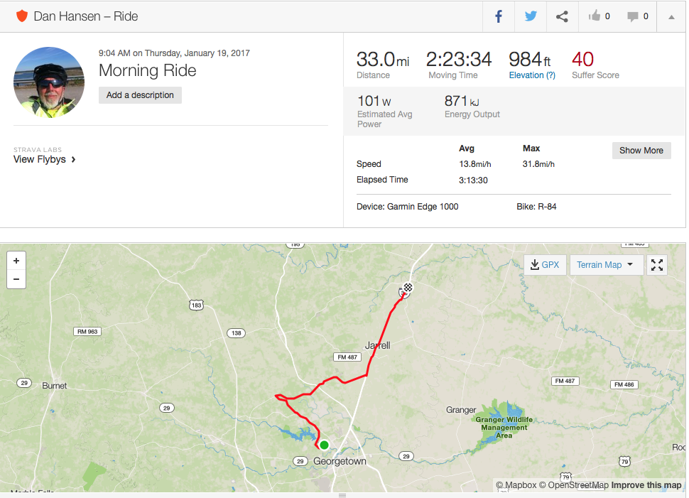 http://www.strava.com/activities/838097757
I had a nice relaxing brunch of 3 breakfast tacos and a very large ice-tea. When I got back outside to the bike the winds had picked up and I could see I was going to have a pretty good headwind for the 25 mile ride back.
Once on my bike I noticed that my Garmin Edge 1000 was being wonky. It stopped being able to track satellites. I could get my other sensors ok (heart rate and cadence) but anything related to GPS was wonked (speed, distance, moving map, directions). Bummer. So, since I had my iPhone with me I started up the Strava app and tracked the ride back with it.
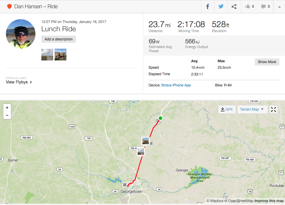 http://www.strava.com/activities/837545521
Winds were pretty good on the way back.
16 Jan 2017, 12:12
Spot Tracker
I carry a Spot Gen3 tracker. This sends tracking messages directly to satellites every 5 minutes. Good for tracking my progress when I’m out of cell phone range. The map will refresh automatically every 5 minutes.
The map shows my last 4 hours of riding. This could be 40 to 60 some miles of riding depending upon my average speed.
14 Jan 2017, 21:29
FastBack System Bag
- 1 Lezyne Multitool (tagged)
- 1 Lezyne Road tire pump (tagged)
- 2 ParkTool steel tire irons (tagged)
- 1 NEW tube repair patch kit (tagged)
- 1 CO2 inflator with 2 cartridges
- 2 28-622 tube (rear R-84 wheel)
- 2 28-406 tube (front R-84 wheel, one with valve extender already on)
- 3 park emergency tire boot
- 2 valve extender (with tools)
- 1 Reading glasses (cheater)
- 1 Quicklink
- 1 Pair SPD cleats and bolts
- 6 Tie wraps
- 1 Red shop rag (tagged)
Red Arkel Seatback Bag
- Road-ID bracelet
- Heart rate monitor (w/new battery)
- Fanny (belly) pack (small and quick on/off bike capability)
On Bike
- Wireless cadence sensor (w/new battery)
- Backup bicycle computer with mileage and at least 6 month battery
10 Jan 2017, 03:08
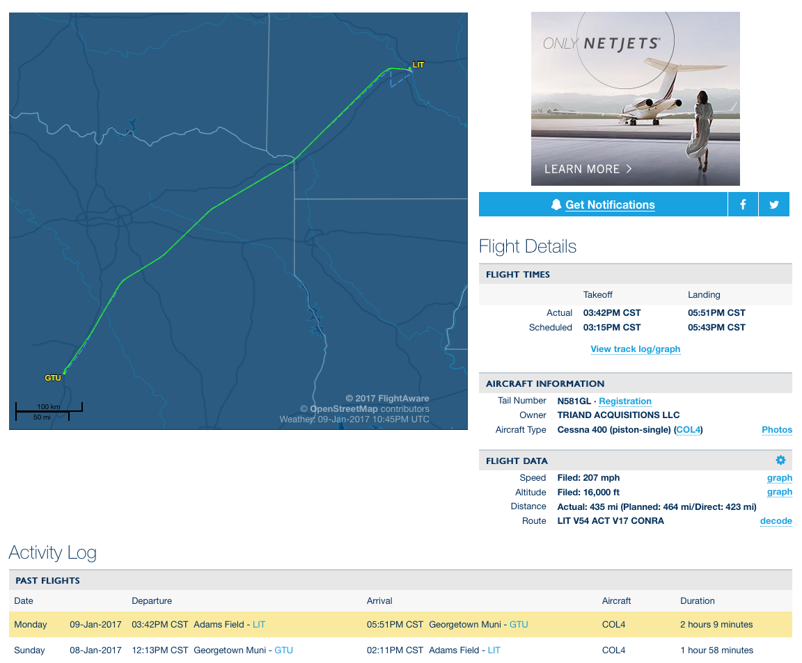
Beautiful day 200 knots at 9000 feet.
Stayed down low to avoid headwinds at higher altitude. Travel time just under 2 hours from Georgetown TX to Little Rock AR.
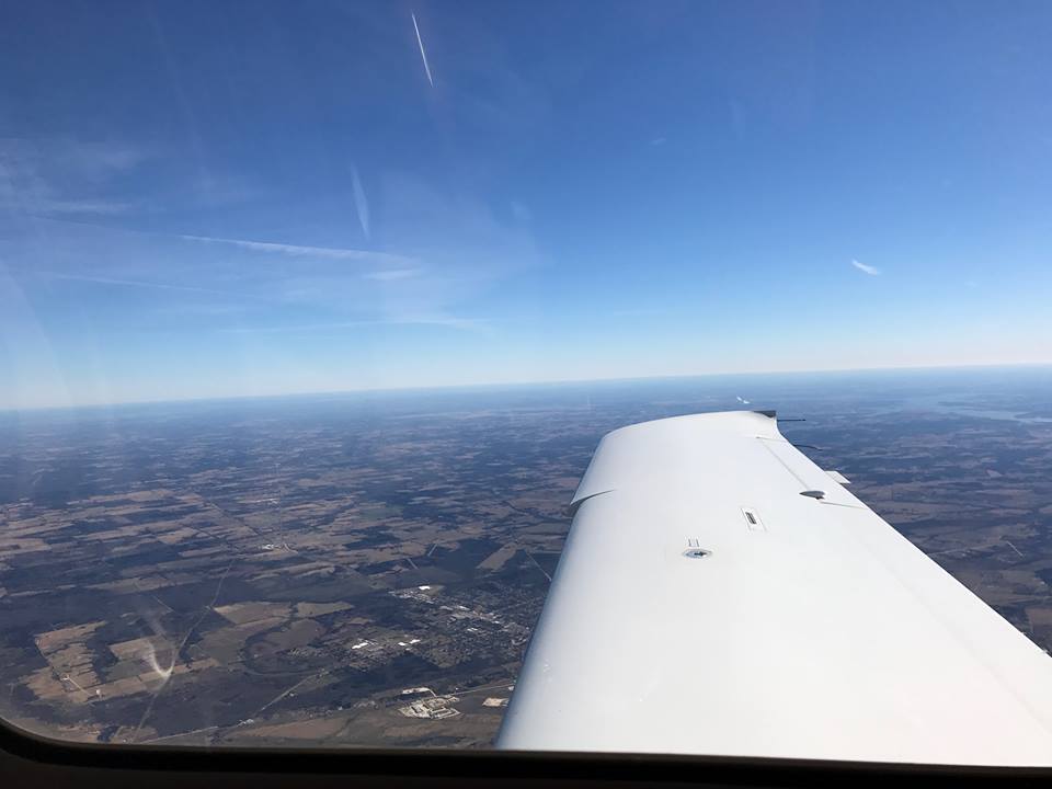
On the way back the next day the winds had changed direction and to avoid a 30 knot headwind I hopped up to 16,000 feet. Above 12,500 feet oxygen is required by the FAA hence the cannula.
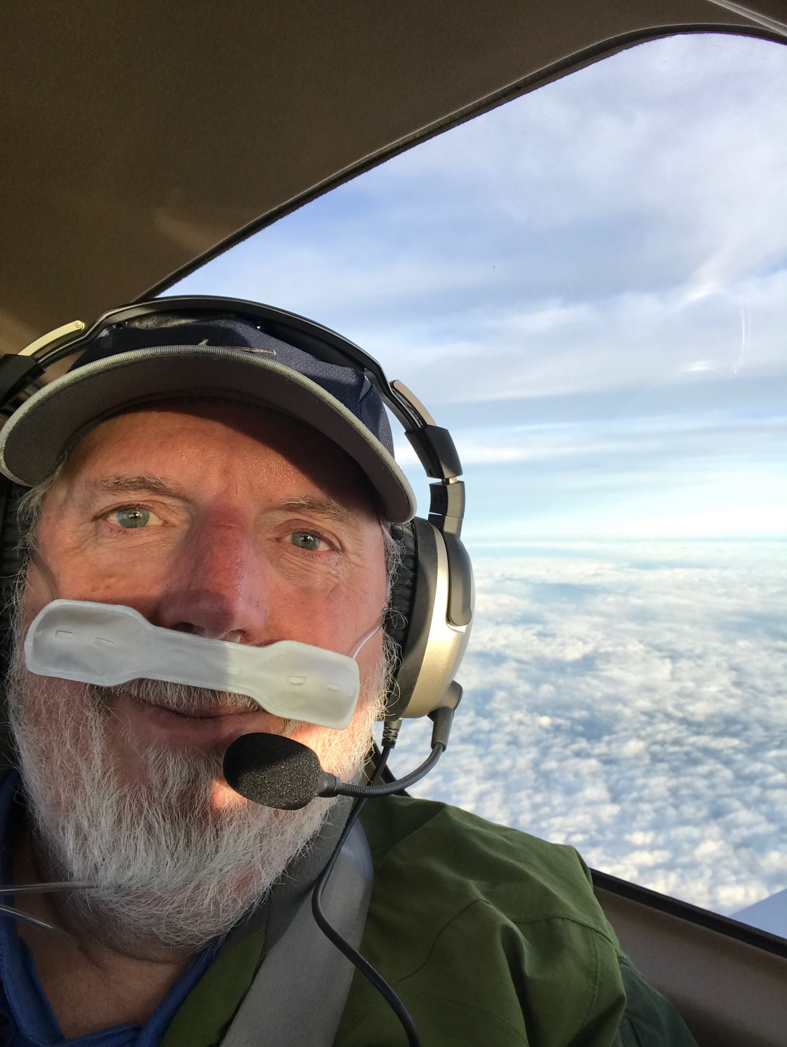
Question on Facebook: “Wow!!! Why so high???”
Faster, smoother, no other traffic.
It was 20 minutes faster getting home at 16k feet. Two hours travel time vs 2 hours and 20 minutes at a lower altitude.
At 8k feet and below there was rough turbulence. At 9k feet there was a 30 knot headwind which kept getting less and less the higher you fly. At 16k feet the headwind was down to 4 knots. And, roughly, for every 1k feet above 10k the plane flys 2 knots faster because of less dense air.
At almost 250 mph this plane is fast. I start my decent about 100 miles out. As I descend over Waco I realise I’m less than 15 minutes from landing at Georgetown.
Since I almost always fly IFR you can usually view my flights on flightaware.com.
